In the northern part of Heilongjiang Province of China and the mountainous area of the Qinghai-Xizang Plateau, there are island-shaped permafrost layers. Due to the nature of the frozen layer as a water barrier, the groundwater in the permafrost regions has its own characteristics. In terms of burial conditions, the groundwater in the permafrost areas can generally be divided into three types: water above the frozen layer, water between the frozen layers, and water below the frozen layer; correspondingly, the local people call this water floating water, waist water, and bottom water (Figure 150).
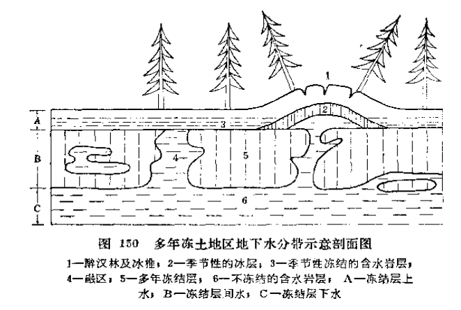
The water in the permafrost layer is the groundwater located in the thawing layer above the perennial frozen layer. Its characteristic is that it is close to the surface, generally receiving recharge from atmospheric precipitation, has a small volume, and during the cold season, the groundwater freezes into ice, while during the warm season, it melts back into water. Therefore, it can only be used as a seasonal small-scale water supply source.
The groundwater existing between the upper and lower boundaries of the perennial frozen layer is the inter-frozen layer water. The inter-frozen layer water with different recharge sources has different properties: the one receiving recharge from the water below the frozen layer has a stable dynamic change and a higher temperature; the one receiving recharge from the water above the frozen layer has a larger dynamic change.
The groundwater buried below the perennial frozen layer is the frozen layer water below. This type of groundwater usually has a confined nature, has a relatively abundant volume, and has a stable dynamic change. It is a reliable water supply source for the perennial frozen soil area and can often meet the needs of medium-sized water supply.
The main methods for finding groundwater in permafrost distribution areas are as follows:
- By visiting areas with perennial frozen layers, such as the forested areas of the Xing’an Mountains, where it is difficult to find groundwater outcrops due to dense forests, and since the outflow and gushing of groundwater in frozen soil areas change greatly with the seasons, it is particularly important to seek clues about underground water sources from local people. For example, in the Sitemu area of the Greater Xing’an Mountains, through visits, a granite fissure rising spring that flows at a rate of 1.2 – 2.3 liters per second was found from the fissures of an ice mound.
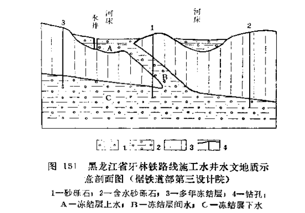
- Search for frozen layer water along the riverbanks. On the riverbanks or near lakes, the groundwater recharge conditions are good, and there is often abundant water stored in the frozen layer. For example, during the construction of the Yaling Line railway in Heilongjiang Province, the frozen layer water near the river was utilized as the water source for both the project and daily use (Figure 151).
- To locate the water beneath the frozen layer, one can observe the dynamic changes of the snow cover. Since the temperature of the water beneath the frozen layer is higher, it often causes the surface snow to melt or freeze into ice after melting. These changes in the snow are indicators for locating the water beneath the frozen layer. For example, in the Shangkulu area of Heilongjiang Province, fourth-order confined water emerges on the surface. According to field observations, there is very little snow cover in the area where the groundwater is distributed, and a 1-kilometer-long and several-decimeter-wide ice cone is formed. The drilling results nearby show that the water head of the confined water is 0.7 meters above the surface, and the single well discharge is more than 250 cubic meters per day.
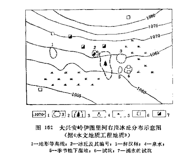
- Ice cones, ice mounds, ice-water rock plates and drunkard forests are unique landforms in permafrost regions and can also be used as indicators for locating groundwater. For instance, on the right bank of Ituri River in the Greater Khingan Mountains, 5 ice mounds with diameters of 20-50 meters were discovered within an area of less than 1 square kilometer. Among them, the 2nd ice mound has a surface uplift of 1.2 meters, a crack length of 20 meters, and a depth of 0.5 meters. There is a spring overflowing from it. The nearby trees, which are over 20 meters high, present a drunkard forest state due to the surface uplift. By digging test pits 2 to 3 meters deep on the ice mounds and their groundwater sources, there is an upward flow of underground water (Figure 152).
- Based on the growth conditions of plants, groundwater can be located in non-permafrost areas. In areas where the groundwater level is shallow, plants that prefer water grow vigorously. In permafrost areas, the situation is similar: in areas where the groundwater level is not deep, due to the freezing of groundwater, the tree roots are unstable and sway, the branches sprout late in spring, the leaves turn yellow in summer, the leaves fall early in autumn, and the branches are sparse in winter. Therefore, based on these growth conditions of the trees, groundwater can also be identified as a sign.
In March 1958, near Gagda in the Greater Khingan Mountains, there was a group of ice spires, 2,000 meters long and 50-100 meters wide. Within the range of these ice spires, the trees were withered and even dead. In July of the same year, when observing the site again, a spring of schist fissure water was found, with a flow rate of 2.3 liters per second. Nearby, there were few plants. - To find groundwater in permafrost areas during winter, when the river water is generally frozen, in areas where groundwater replenishes the river, the ice layer is very thin and even the water flows turbulently, with misty vapor.
When conducting water source surveys in the Greater Khingan Mountains, this method was used. There was a section of river where the ice thickness in winter was only 10 centimeters. After surveying, the underground water source was found to be abundant. - Using geophysical exploration, drilling, and other methods to search for groundwater. The resistivity of the permafrost layer is very high, which is conducive to quantitative analysis by electrical measurement. The Ministry of Railways used ground geological surveys, combined with electrical exploration, drilling and other exploration methods, to search for groundwater along the newly built railway line in the Greater Khingan Mountains, and achieved good results.