New PQWT S300 Geological Long Range Underground Water Detector 300m Ground Water Groundings Detector Water
How to find underground water by studying the geological structure and changes?
1. PQWT Automatic Mapping Water Detector can
easily find groundwater resources and profile on site by ONE key on the host.
easily find groundwater resources and profile on site by ONE key on the host.
2. Geological structure and specific information
such as aquifers, fractures, faults, and caves can be easily analyzed through automatic mapping curve.
such as aquifers, fractures, faults, and caves can be easily analyzed through automatic mapping curve.
3. PQWT underground water detector can be widely used in different terrains such as plains, hills,
mountains, plateaus, and basins for rapid analysis of geological structure changes and determines
the water well drilling points, aquifers, and aquifer depth.


Introduction:
underground water detector is the use of natural earth field source without going through artificial field that is
underground water detector is the use of natural earth field source without going through artificial field that is
omitted clumsy power supply system in order to achieve the simple, lightweight. After data collection,
instrument through the unique built-in computing functions to achieve the automatic presentation graph,
the collected data can also be transferred to a computer drawing
to form a cross-sectional view, the geological layer structure can be quickly determined by a clear
to form a cross-sectional view, the geological layer structure can be quickly determined by a clear
understanding of rock frame , karst cave, aquifer etc.

Specification


|
1. High Speed and High Efficiency Complete more than 8000 meters profile measurement in one day to realize geological
abnormalityin different depth, the prospecting speed and efficiency are improved about 10 times more than traditional resistivity method. |
|
2. Easy to CarryWithout the heavy power supply, it uses low-frequency signals in earth natural electric field as the signal
source, and the complete set weight is less than 2kg so easy to carry |
|
3. Simple OperationEquipment is automatically controlled by the micro PC. You can learn its operation in 10 minutes. It will take0.5h for persons
without prospecting experience to finish training. |
|
4. Good Accuracy, High Accuracy The resolution of the measurement is up to 0.001mV, and precision is ±2%. It gains high stability
and abnormity curves matching with that of traditional geo-electrical equipment in lots of field survey. |
|
5. Anti-interference Ability It has advanced anti-jamming technology and multiple anti-jamming designs. You can observe abnormity
curves result with good repetition even in the weak signal area, city, high electric jamming area and working area with other exterior interference via frequency selector and digital processing. |
|
6.A key to mappingThe detector is fully automatic form mapping after sampling data no need the computer drawing mapping
|
|
Product model
|
PQWT-s300
|
|
Measuring depth
|
100/ 150 /300 Meters
|
|
Measurement data unit
|
electric field component of different frequencies of the earth electromagnetic field ΔVs (mV)
|
|
Measuring range
|
0mV-1500mV
|
|
Measurement accuracy
|
0.001mV
|
|
Measuring channel
|
3 channels
|
|
Measurement frequency
|
Single, Triple, 36/40frequency
|
|
Display
|
Industrial 7-inch HD touch screen LED
|
|
Power
|
3.7V 4000mAh Rechargeable lithium battery
|
|
Weight
|
0.55kg (host)
|
Configuration table
|
Host machine
|
1set
|
|
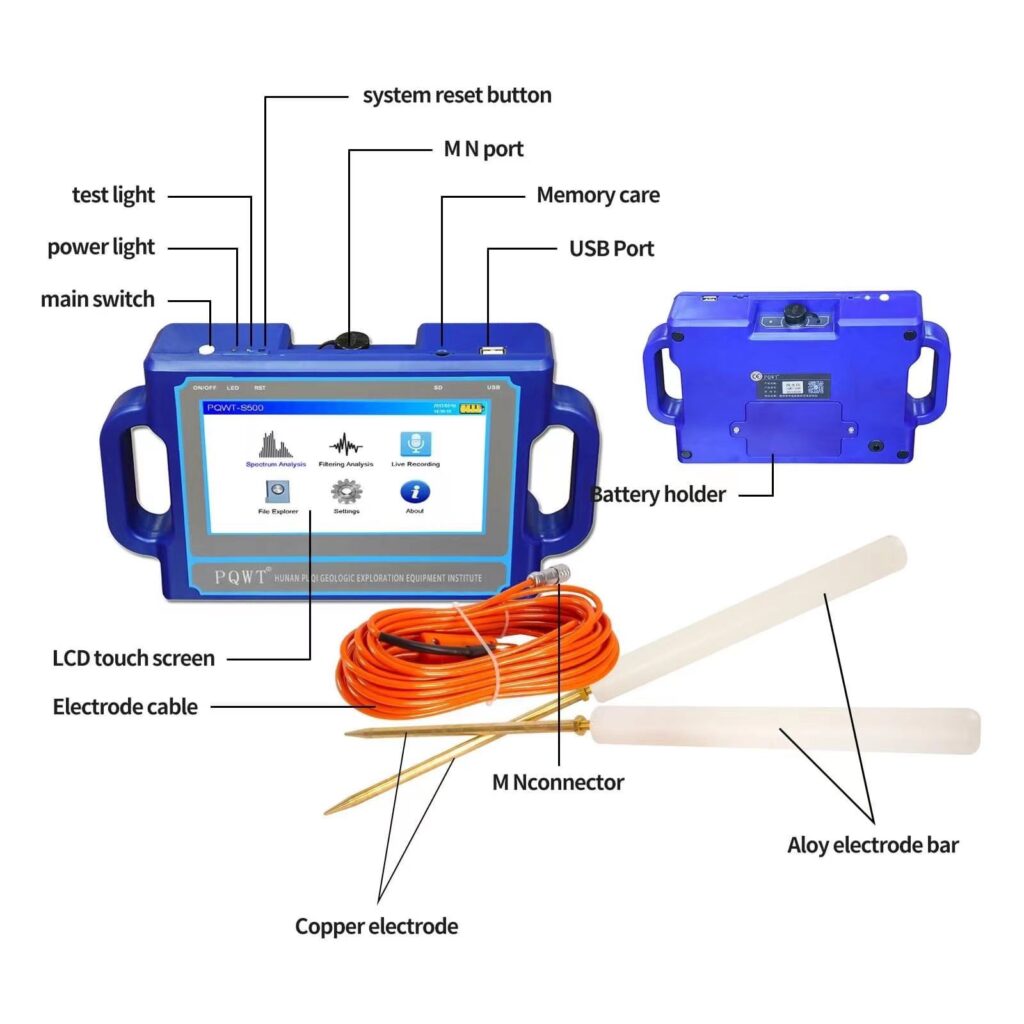
Electrode Cable
|
1pc
|
|
Charger
|
1pc
|
|
Alloy Electrode Bar
|
1pair
|
|
Copper Electrode
|
1pair
|
|
USB stick
|
1pc
|
|
Universal adapter plugs
|
1pc
|
|
Flight case
|
1pc
|


Packing & Delivery

